Ohio has 27 roads designated by the state as Ohio Scenic Byways, offering adventures, historic sites and relaxing scenery as an alternative to the “quickest way from A to B” type of traveling. Six of these roads are also designated as America’s Byways by the Federal Highway Administration.
Amish Country Byway (America’s Byway) — 160 miles of natural vistas with winding curves, rolling hills, Amish buggies, bustling towns and beautiful farmlands in Holmes County. Start with SR 39 and US 62, but choose just about any road in Ohio’s Amish Country and you’ll probably find it has been designated as a scenic byway.
Appalachian Byway – This 105-mile byway connects with the Ohio River Scenic Byway with the Hannibal Locks and Dam on SR 7 in Hannibal, Ohio; then to SR 78 through Monroe County into Noble County and Morgan County ending in Nelsonville in Athens County. You can also take SR 83 to The Wilds in Muskingum County and then south along SR 284 to pick up the byway again.
Big Darby Plains Scenic Byway – This runs mainly parallel to the state and nationally designated Scenic Big Darby Creek for more than 27 miles through Union, Champaign and Madison counties. The byway includes access to the scenic river, nature preserves and parks. There are also several covered and historic bridges, century farms, cemeteries and homes of interest along the routes as it passes by North Lewisburg and through Milford Center, Unionville Center and Plain City.
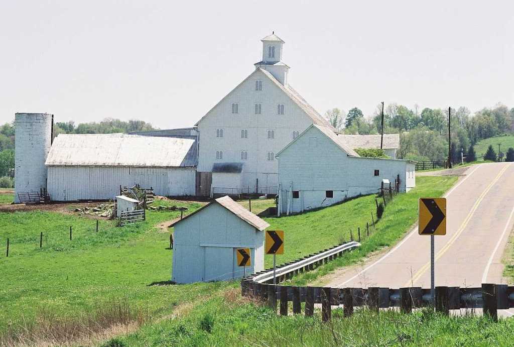
Drovers’ Trail Scenic Byway – The Drovers’ Trail Scenic Byway in Belmont County follows SR 800 between Hendrysburg and Barnesville and SR 147 from Barnesville to Bellaire. It consists of beautiful scenic vistas and features historic homes, architecture and sites located on the 37-mile stretch of road. This byway connects two other Scenic Byways (the Historic National Road and the Ohio River Scenic Byway) and has a long history in transportation. In the 19th century it was a heavily traveled route vital to both travelers and farmers transporting goods to markets.
Granville Scenic Byway – Granville Scenic Byway, an approximately 10-mile route, begins at SR 37, intersects with James Road and continues north onto SR 661 through the Village of Granville along the eastern campus of Denison University. It ends just north of Cambria Road at the north boundary of Granville Township in Licking County. Byway attractions include rolling hills, scenic farms, ancient burial grounds, pleasant residential districts and Denison University, an independent college on a beautiful campus with a mixture of historic and contemporary buildings.
Heritage Corridors of Bath – Originally part of the Connecticut Western Reserve, the Heritage Corridors of Bath connects 19th century hamlets with the Hale Farm and Village, the Bath Nature Preserve and Cuyahoga Valley National Park. Historic homes, barns, cemeteries and mills line the byway as it winds through areas of scenic and natural beauty. The byway is best accessed by taking I-77 to Ghent Road (exit 138), turning north onto Ghent Road, which ends at Cleveland-Massillon Road, and continuing (north) onto North Cleveland-Massillon Road to the beginning of the byway.
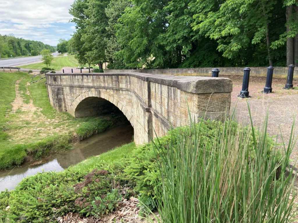
Fox Run S-Bridge on the National Road along U.S. 40 just west of New Concord.
Historic National Road (America’s Byway) – The Historic National Road Byway is lined with “pike towns” that grew up around stopping points for foot and horse powered traffic in the early 19th century. In Ohio, the byway (including and paralleling US 40) extends from the West Virginia state line at the Ohio River to the Indiana state line, 225 miles long. Most of the alignment of the National Road was incorporated into US 40 when the national route system went into effect in 1926. Replica stone mile markers are placed along the route.
Hocking Hills Scenic Byway (America’s Byway) – This 26.4-mile byway follows SR 374 through Ohio’s scenic Hocking Hills and around Hocking State Forest. Byway visitors are treated to some of the most dramatic scenery in Ohio, with rock formations, caves, waterfalls, cliffs and forested trails. The Hocking Hills region has something for everyone, including hiking, cabins, zip lines, horseback riding, canoeing and hot air ballooning.
Jefferson Township Scenic Byway – Although Jefferson Township is located in Franklin County, a portion of the township is a remnant of rural and natural character amid sprawling subdivisions. The sections of the 10 roads that make up the byway offer scenic vistas of older barns and homes, many dating from the early 1800s, along with streams, slopes and stands of trees.
Johnny Appleseed Historic Byway – Explore over 30 miles of byway along SR 39 between Loudonville and Mansfield and SR 603 between the Village of Mifflin and Malabar Farm, celebrating the life of John Chapman, legendary orchardist and nurseryman. Historic sites along this byway include Chapman’s original landholdings and nurseries as well as original sites of Native American culture and pioneer settlements.
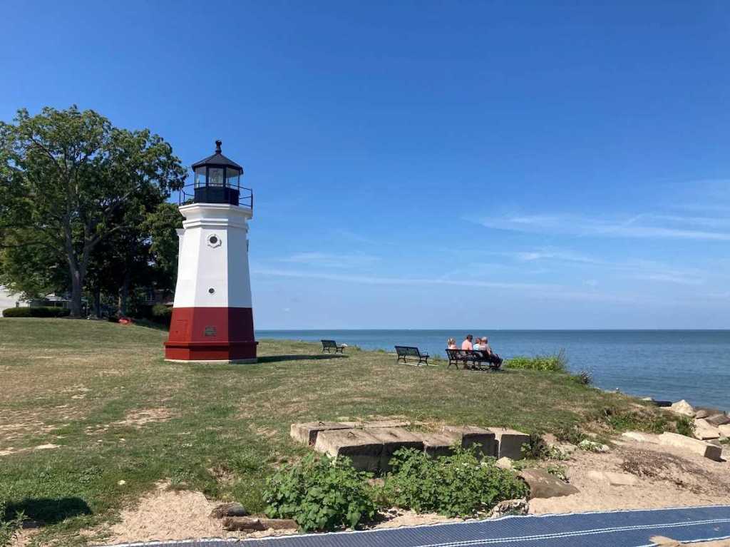
Vermilion’s lighthouse looks out on Lake Erie. Vermilion is part of the Lake Erie Coastal Scenic Byway.
Lake Erie Coastal Scenic Byway (America’s Byway) – The 293-mile Lake Erie Coastal Ohio Scenic Byway offers travelers beaches, state parks, preserves, lighthouses, vacation islands, quaint villages and big cities. This byway offers shopping, fishing, birding, biking, boating, camping, touring and exploring, truly a scenic byway with something for everyone. Historians will enjoy the rich maritime history tours while recreation boaters never run out of things to do. A trip to Lake Erie Coastal Ohio can last all day or all week. From east to west, the byway starts at Conneaut and closely follows the coastline before ending at the Michigan border near Toledo.
The Land of the Cross-Tipped Churches Byway – The Land of the Cross-Tipped Churches Byway travels through Shelby, Auglaize and Mercer counties, beginning in McCartyville. It then travels along SR 119 to Fort Recovery, and proceeds north along SR 49 until it ends at SR 29 west of Wabash. This 38.4-mile long scenic route encompasses many of the grand historical aspects of the early settlers of the region. An array of cross-tipped churches can be viewed endlessly as one travels through this virtually level farming region. These structures were entered into the National Register of Historic Places in 1979.
Lincoln Highway Historic Byway – The Lincoln Highway was the first roadway system in support of the car. Beginning in New York and ending in San Francisco, it was conceived in 1913 as the first highway from the Atlantic to the Pacific that would carry motor traffic. The 241-mile section (primarily US 30) through Ohio was modified a number of times from 1913 until 1928 to route the road more directly to Chicago. The byway follows the final 1928 alignment, which connected the cities of Canton, Massillon, Wooster, Mansfield, Bucyrus, Upper Sandusky, Delphos and Van Wert.
Lower Valley Pike Byway – This 11-mile byway along Clark County Road 316 closely follows the Mad River and passes George Rogers Clark Park, 250 acres of green meadows, shade trees, wildlife and a lake with a small waterfall. In addition, the park is the site of the largest battle of the Revolutionary War west of the Allegheny Mountains, and the fair at New Boston. The fair is held annually during Labor Day weekend and gives a glimpse of 18th century life. Other byway highlights include the historic Hertzler House and the 167-acre Estelle Wenrick Wetlands Preserve.
Maumee Valley Scenic Byway – The nearly 90-mile route begins on the north side of the Maumee River in Defiance at the intersection of SR 15 and River Drive (CR 424). The byway follows River Road eastward through Napoleon, Waterville and into Maumee to the site of the former British Fort Miamis, now a city park, where it ends. On the south side of the Maumee, the byways starts at Napoleon on SR 110 and continues on SR 65 through the historic towns of Grand Rapids, Perrysburg and Rossford, ending at I-75.
Miami and Erie Canal Scenic Byway – This 54-mile byway in Miami and Allen counties follows SR 66 and part of the original route of the Miami and Erie Canal, an important 19th century transportation route from Lake Erie to Cincinnati. Canal operation peaked between about 1840 to 1860 and was replaced by the railroads. Visitors can enjoy a canal boat ride at the Johnston Farm & Indian Agency, and hike through the many trails and state parks near the byway.
Neil Armstrong Scenic Byway – This byway celebrates the early years of NASA Astronaut Neil Armstrong’s life with special emphasis on the time period in which he obtained his pilot’s license. Highlights include the Armstrong Air & Space Museum and downtown Wapakoneta.
North Ridge Scenic Byway – This 9-mile byway encompasses the entire length of SR 254 in Lorain County and passes by more than 100 historic homes that date back to the 1830s.
Ohio & Erie Canalway (America’s Byway) – The Ohio & Erie Canalway America’s Byway approximates travel alongside the historic path of the Ohio & Erie Canal, the nation’s first inland waterway link between the Great Lakes and the Gulf of Mexico. The byway closely follows the former canalway from Dover to Cleveland. Twenty miles of its route drives directly through the heart of Cuyahoga Valley National Park.
Ohio River Scenic Byway (America’s Byway) – Spanning 14 counties in southern Ohio, this byway encompasses the entire length of the Ohio River in Ohio, a total of 452 miles. Starting at US 50 at the Indiana border, this route follows US 52, SR 7, SR 124 and SR 39 to East Liverpool at the Pennsylvania border. The Ohio River Scenic Byway is also in Indiana and Illinois and is designated a National Scenic Byway. This byway offers travelers scenic views of the lush Ohio Valley and small river towns with important historical significance to the state as well as the country.
Old Mill Stream Scenic Byway – The Old Mill Stream Scenic Byway follows the Blanchard River along US 224 and SR 37 in Putnam and Hancock counties. The byway takes its name from the 1910 song, “Down by the Old Mill Stream.” The tune was written by Hancock County native Tell Taylor while he sat on the banks of the Blanchard. The byway offers its visitors a pastoral trip through the countryside, featuring parks, farms and historic settings.
Olentangy Heritage Corridor – Spanning only 10.5 miles, the Olentangy Heritage Corridor Byway begins at I-270 in Franklin County and continues to follow the ancient Indian trails of the Olentangy River to US 23 in Delaware County. SR 315 was also documented as the first road commissioned in Delaware County in August 1808, and it remains a significant north-south road now. Travelers enjoy the scenic Olentangy River on one side of the byway and picturesque barns, churches and houses on the other.
Quaker Scenic Byway – The 54-mile Quaker Scenic Byway celebrates the migration of Quaker settlers in Ohio. This scenic loop in southwest Ohio, primarily in Clinton and Warren counties, offers sites including Quaker meeting houses and the first school for free African Americans in Harveysburg. This scenic byway intersects with the Little Miami Scenic Trail and Caesars Creek State Park and is connected by two historic towns, Waynesville and Wilmington.
Scioto Heritage Trail – Beginning in downtown Portsmouth, the byway ties into the Ohio River Scenic Byway near the Portsmouth murals. Heading west, it then follows the Ohio River and turns north into the Shawnee State Forest, the largest of Ohio’s 20 state forests. Highlights are birthplaces of two famous Ohioans, Roy Rogers and Branch Rickey. The byway travels along the highest elevations in Scioto County and provides historic sites and scenic views overlooking the valley below.
Tappan-Moravian Trail – This 55-mile byway winds through Tappan Lake and Clendening Lake regions and back through some of eastern Ohio’s most charming rural landscapes including family farms, lush fields and beautiful water scenes. New Rumley along SR 646 is the birthplace of George Armstrong Custer where a memorial marks the spot. And Deersville, Ohio’s main street has recently been placed on the National Register of Historic Places.
Wally Road Scenic Byway – The scenic beauty of the forested hilltops, deep ravines, wetlands and rich soil bottom lands of the Mohican and Walhonding valleys was restricted to a few river travelers and remote villages before the Toledo, Walhonding Valley and Ohio Railroad (the “Wally”) opened a 45-mile connecting route from Coshocton to Loudonville in 1892. This route was considered one of the most scenic train rides in Ohio. The railroad ceased operations in 1942, but part of the route lives on as the Wally Road Scenic Byway.
Welsh Scenic Byway – This 64-mile byway that includes US 35 and SR 93 loops through Gallia and Jackson counites and celebrates the Welsh immigrants who settled in southeastern Ohio during the 19th century. The byway connects many Welsh churches, farms and cemeteries. Visitors are treated to pastoral farms, including the Bob Evans Farms Homestead, quaint cemeteries and wildlife areas that include Raccoon Creek where Daniel Boone hunted and trapped.
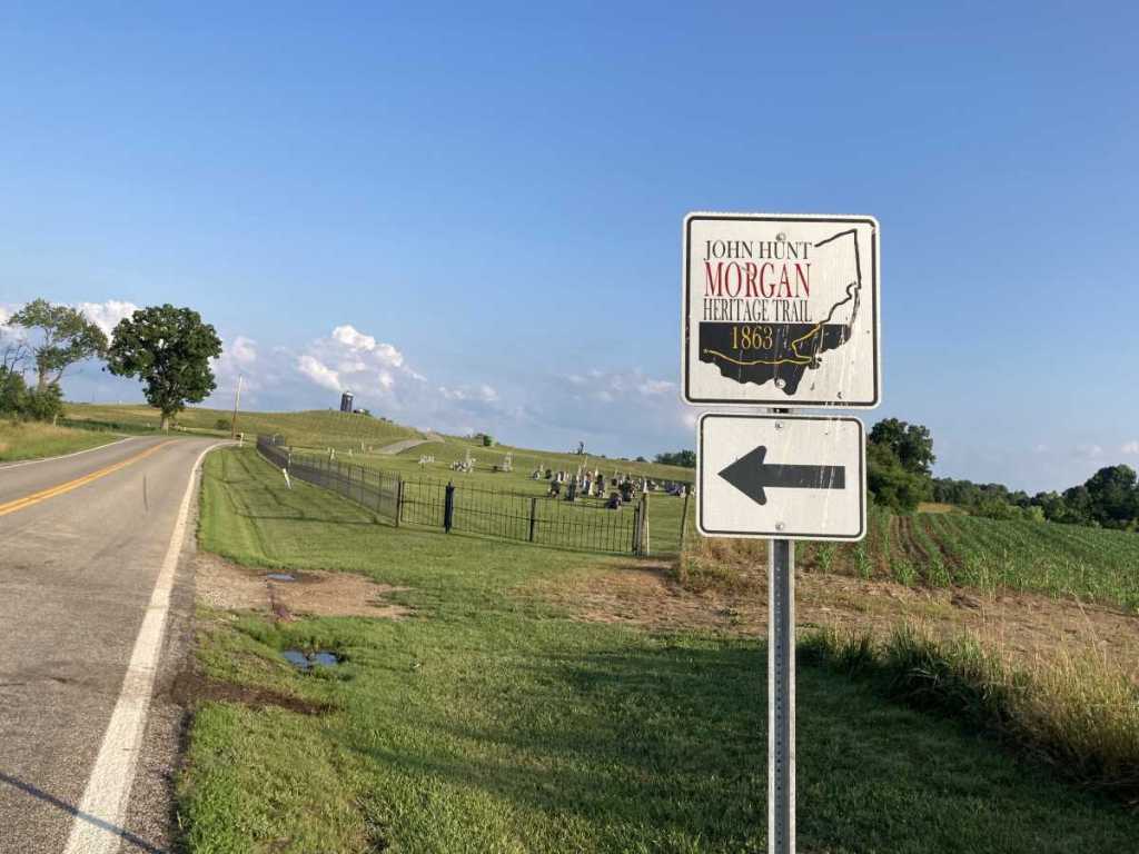
This John Hunt Morgan Heritage Trail marker is located along SR 669 in Morgan County.
Other Ohio Routes
Ohio Art Corridor – The Ohio Art Corridor is a public art trail that features murals, oversized sculptures, art galleries and more as it winds through Ohio’s scenic Appalachian region. The corridor has incorporated existing pieces of art in Circleville, Lancaster, Athens, McConnelsville, Zanesville and Portsmouth. Along this route you’ll find the Ohio Glass Museum in Lancaster, a growing arts community in downtown Zanesville, the Dairy Barn Arts Center in Athens, Ohio River floodwall murals in Portsmouth, and much more.
Ohio Underground Railroad – Visit these Underground Railroad sites in Ohio that were crucial to providing safe passage for slaves fleeing the South to Canada prior to and during the Civil War. John Rankin House (Ripley); Nelson T. Gant House (Zanesville); Kelton House Museum & Garden (Columbus); Follett House Museum (Sandusky); Hubbard House Underground Railroad Museum (Ashtabula). Also visit the National Underground Railroad Freedom Center (Cincinnati).
John Hunt Morgan Heritage Trail of Ohio – The John Hunt Morgan Heritage Trail follows the route of Confederate Brig. Gen. John Hunt Morgan’s Great Raid of July 1863. The cavalry unit rode through Federal-held areas in Tennessee, Kentucky, Indiana and Ohio before the main unit was finally captured in eastern Ohio. This unique Ohio driving tour begins at Harrison and ends 557 miles later near West Point. The tour includes the only Civil War battle fought on Ohio soil, the Battle of Buffington Island. It features 56 interpretive wayside exhibits and over 600 directional signs.
(Source: Ohio Byways/Ohio Department of Transportation https://www.transportation.ohio.gov/traveling/ohio-byways), American Battlefield Trust (https://www.battlefields.org/visit/heritage-sites).
All rights reserved, copyright Dusty Tires (dusty-tires.com), 2023.
