Mink Hollow Covered Bridge is located at 2340 Meister Road SW, spanning Arney Run in Fairfield County. The bridge was built in 1887.
Well over 100 historic covered bridges exist in Ohio, many of them still in use. The top two counties for covered bridge sightings are Ashtabula and Fairfield counties. Here are a few of them:
- Smolen-Gulf Covered Bridge is the longest covered bridge in the United States, at 613 feet long, crossing the Ashtabula River at 4878 Plymouth Ridge Road, Ashtabula.
- Rock Mill Covered Bridge, built in 1901, is at Stebelton Park at Rock Mill next to the restored Rock Mill. The bridge spans a waterfall of the Hocking River. Located at 1429 Rockmill Place NW near Lancaster in Fairfield County.
- Roberts Covered Bridge in Eaton is the last two-lane, “double-barreled” covered bridge in Ohio. Constructed around 1929-30, the bridge was built to cross Seven Mile Creek. The bridge was moved to 315 S. South Beech St., Eaton, in 1991.
A good starting point for more information about Ohio’s historic covered bridges is the Touring Ohio website. Another excellent website with much information and photos is The Covered Bridges of Ohio (https://coveredbridges.net/state/ohio).
There are other interesting bridges in Ohio as well — for example the famed Y-Bridge in Zanesville and S-shaped bridges that span waterways along the National Road.
Here is a list of historic (pre-1970) covered bridges by county. The word “or” indicates more than one name for a covered bridge. The list below is derived from Round Barns and Covered Bridges by Dale J. Travis.
Adams: Harshaville (1855), Kirker (1890).
Ashland: Mohican State Park (1969).
Ashtabula: Olins or Dewy Road (1873), Creek Road (1880), Middle Road (1868), Root Road (1868), Benetka Road (1900), Graham Road (1867), South Denmark Road (1868), Mullen or Doyle Road (1876), Mechanicsville (1867), Harpersfield (1868), Riverdale (1874), Callander Road (1870), Warner Hollow (1867), Hollow Road or South Windsor Road (1870), Covered Bridge Pizza (1862).
Athens: Palos (1875), Kidwell (1880), Blackwood (1881).
Belmont: Schaeffer or Campbell (1875).
Brown: Brown (1878), New Hope or Bethel Road (1878), McCafferty Road (1877), North Pole Road (1875), George Miller (1879).
Butler: State Line or Bebb Park (1868), Black or Pughs Mill (1868).
Clermont: Perintown or Stonelick (1878).
Clinton: Martinsville Road (1871), Lynchburg (1870).
Columbiana: Sells or Roller Mill (1878), McClelland or Kinmuer (1871), Teegarden or Centennial (1876), Church Hill Road (1870), Thomas J. Malone (1870).
Coshocton: Helmick (1863).
Delaware: Chambers Road (1883).
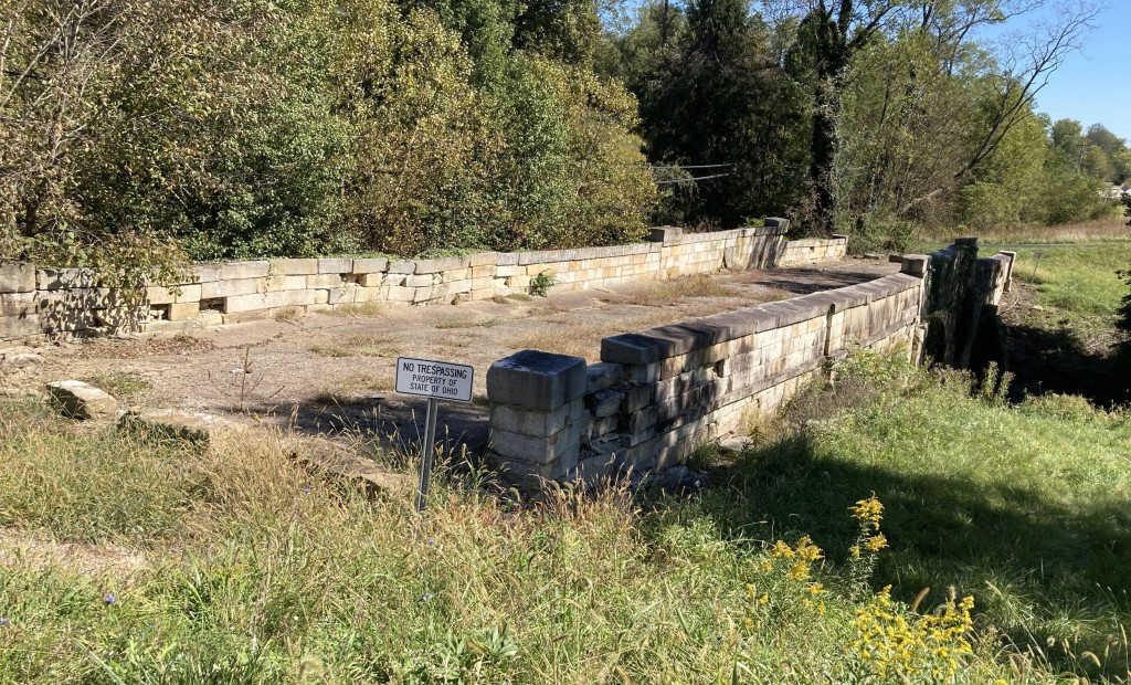
Rock Mill Covered Bridge is located adjacent to the restored Rock Mill in Fairfield County.
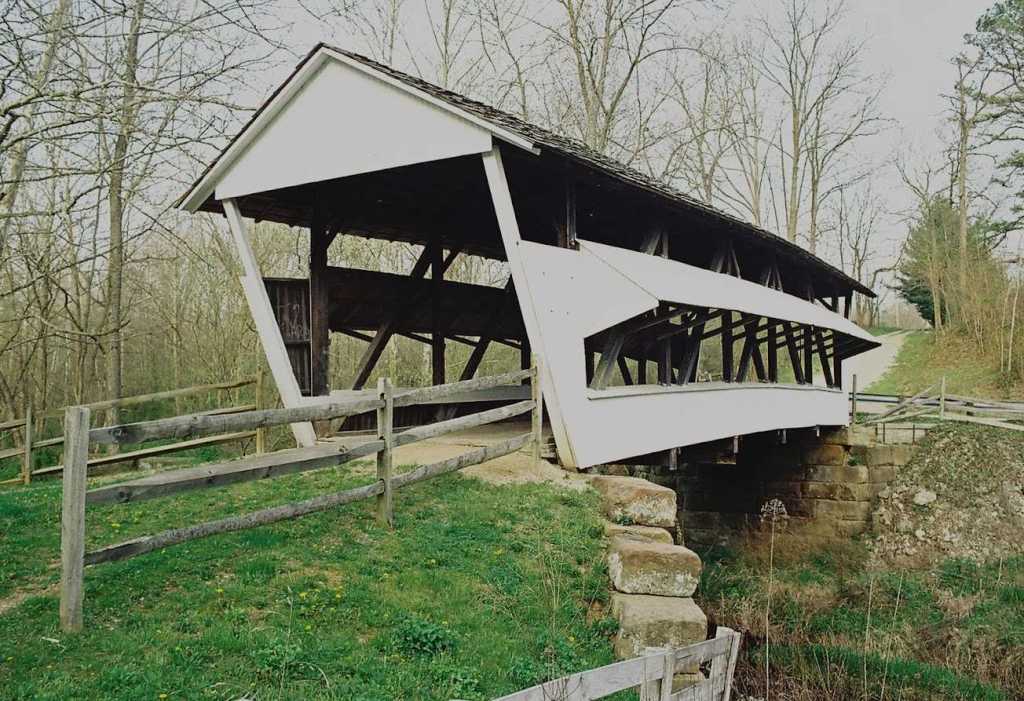
Fairfield: Hizey or Visintine (1891), John Bright #2 (1881), George Hutchins (1904), Hannaway (1901), Johnston (1887), Zeller or Smith (1906), McCleery (1864), Shreyer (1891), Charles Holliday (1897), R.F. Baker (1871), Jon Raab (1891), Hartman #2 (1888), Mink Hollow (1887), Rock Mill (1901), KSA Ranch (1967).
Franklin: Bergstresser or Dietz (1887).
Greene: Cemetery Road or Glen Helen (1886), West Engle Mill Road (1877), Stevenson Road (1877), Ballard Road (1883).
Guernsey: Indian Camp (1855), Armstrong or Clio (1849).
Hamilton: Jediah Hill or Groff Mill (1850).
Jackson: Crabtree or Johnson Road or Petersburg (1870), Byer (1872), Buckeye Furnace (1871).
Knox: Bridge of Dreams (1920s).
Lake: Wersch Estate (1940).
Lawrence: Scottown or Pleasant Ridge (1874).
Licking: Shoultz or Girl Scout Camp or Mercer (1879), Gregg Mill or Pine Bluff or Handel (1881), McLain-Lobdell Park (1871), Davis Farm (1947).
Logan: McColly (1876), Bickham (1877).
Lucas: Sleepy Hollow (1962).
Mahoning: Evergreen Acres (1961).
Miami: Eldean (1860).
Monroe: Foraker (1886).
Montgomery: Germantown (1865), Feedwire Road (1870), Jasper Road or Mud Lick (1877), MM Jameson (1962).
Helmick Mill Covered Bridge near Eagleport in Morgan County sits above Island Run cascading over rocks under the bridge.
Morgan: Barkhurst Mill (1872), Helmick Mill (1867), San Toy Creek (1875), Milton Dye (1915).
Muskingum: Johnson Mill or Salt Creek (1876).
Noble: Manchester (1915), Parrish (1914).
Perry: Hopewell Church (1874), Jacks Hollow (1879), Bowman Mill or Reddington (1859), Mary Ruffner or Moore (1875).
Pickaway: Valentine or Ole Bill Green (1887), Blackburn or Brannon or Wesner (1885).
Preble: Harshman (1894), Dixon Branch (1887), Roberts (1829), Brubaker (1887), Christman (1895), Geeting (1894), Warnke (1895).
Ross: Buckskin (1873).
Sandusky: Mull (1851).
Scioto: Otway (1874).
Stark: Fairlane Farm (1958).
Summit: Everett Road (1870).
Trumbull: Newton Falls (1831).
Union: Pottersburg or Upper Darby (1868), Spain Creek (1870), Culbertson Winget Road or Treacle Creek (1868), Axe Handle Road or Bigelow or Little Darby (1873).
Vinton: Mt. Olive or Grand Staff (1875), Bay or Tinker (1876), Eakin Mill or Arbaugh (1870), Cox (1884).
Warren: Leslie Rothman (1969).
Washington: Shinn (1886), Henry (1894), Root or Qualey (1878), Harra (1878), Bell (1888), Mill Branch (1885), Schwenderman (1894), Hills or Hildreth (1878), Hune (1879), Rinard (1876).
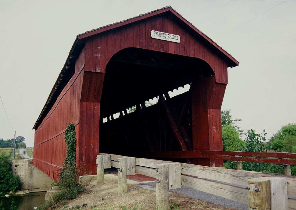
Swartz Covered Bridge, built in 1878, spans the Sandusky River. The bridge is located on County Road 130A about 8 miles southeast of Upper Sandusky in Wyandot County.
Wyandot: Parker (1873), Swartz (1878).
OTHER INTERESTING BRIDGES
Other bridges of interest include several bridges along the Historic National Road (roughly the route of current-day US 40), the Great Stone Viaduct in Bridgeport, and well as the famous Y-Bridge that connects US 40 and Linden Avenue in Zanesville across the Muskingum and Licking rivers.
Reciprocity Bridge along US 40 west of Zanesville.
National Road bridges. The Reciprocity Bridge is a stone arch bridge along US 40 west of Zanesville. According to the Ohio National Road Association, this bridge was named Reciprocity (“tit for tat”) for a Congressional inspection committee composed of representatives from Indiana and Ohio, who cut a deal about the National Road as they were riding toward the bridge.
S-bridges are another unique feature of the National Road. When the road was originally built in Ohio from 1825 to the late 1830s, the roadway seldom approached streams at a 90-degree angle, particularly in hilly eastern Ohio. The S-shape allowed waterways to be crossed at a 90-degree angle while maintaining the direction and location of the road.

The Fox Run S-Bridge is located just west of New Concord on US 40.
Here are some bridges along the road:
- Blaine Hill S-Bridge, built in 1828 (53717-53723 Pasko Road, Bridgeport) is 385 feet long with three segmented arches.
- Salt Fork S-Bridge, in Middlebourne on County Road 6794 (Bridgewater and Blend roads).
- Peters Creek S-Bridge, built in 1828, is at the north side of US 40 west of Cambridge at Peter’s Creek Road.
- Fox Run S-Bridge is located in a park just west of New Concord (north side of US 40).
- John Carnahan Bridge, one of the few bridges signed by its engineer, is located on Old National Road just west of I-70’s National Road exit.
- Reciprocity Bridge, a stone arch bridge built in 1830, is located along US 40 at Mount Sterling (near Hopewell).
- Stone arch bridge located just west of Gratiot.
The Great Stone Viaduct, consisting of 43 stone arches, was built in 1871 by the Central Ohio Railroad to carry north and eastbound rail service across the Ohio River (31st Street, Bellaire).
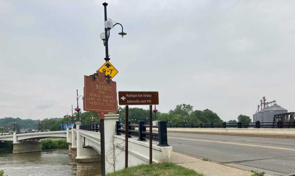
The current Y-Bridge in Zanesville was built in 1984 and replicates the design of the 1902 bridge.
The Y-Bridge is the only bridge where you go to the middle and turn left or right. The bridge first opened to traffic in 1814 and was rebuilt in 1819, 1831 and 1902. The current bridge was built in 1984 and replicates the design of the 1902 bridge, which was badly damaged in the great flood of 1913. The bridge is located on US 40 or Main Street in downtown Zanesville. For a birds-eye view of the bridge, go to Putnam Hill Park, off Pine Street south of downtown Zanesville.
To learn more about the history of the National Road, visit the Zane Grey/National Road Museum in Norwich just off I-70. (Hint: A great little daytrip consists of visiting this museum along with the John and Annie Glenn Home in New Concord, and maybe some of the antique malls along US 40 between New Concord and Zanesville. Then stop at Tom’s Ice Cream Bowl in Zanesville.)
All rights reserved, copyright Dusty Tires (dusty-tires.com), 2023.
